Northern End Of Pumicestone Passage Speed Limit Submission
Preamble
TAPP (Take Action for Pumicestone Passage) Inc. presents the following submission because of our concern to protect, restore and enhance the Pumicestone Passage as a significant part of the Moreton Bay Ramsar Wetlands. TAPP invited eleven local community groups to respond to this Submission and all eleven groups support the Submission. Their responses are included as part of this Submission.
The feedback from these community groups reinforced their support for the Submission. Their feedback included reference to a recent survey conducted by Golden Beach and Pelican Waters Community Association Inc which identified the local community concerns about overuse of the Passage, the big increase in water-skis using the Passage and the growing erosion problem on both the foreshore and the Bribie Island sides at the northern end the Pumicestone Passage.
It was noted that the navigation channels can continue to be management without any difficulty with the suggested changes to the speed limit. It was also pointed out that there is plenty of room for water skiing and motorised PWCs in the area south of Bells Creek. Already the more responsible PWC owners use this area.
A recent archaeological survey conducted on behalf of the Kabi Kabi First Nation Native Title Claimant Group and Healthy Land and Water found that due to increased erosion in Bells Creek, First Nation middens are being damaged and the draft Report on this study recommends a reduction of speed in Bells Creek.
The aspiration of many participants attending the Pumicestone Catchment Convergence 2021 in February at the University of the Sunshine Coast was that the Passage as part of the Moreton Bay Ramsar Wetlands be assigned a speed of 6-10 knot for all water craft using the Passage. In the interests of moving toward a compromised position acceptable to current users of the Passage, TAPP makes the following submission.
- Current Situation
1.1 The 6 knots (11kph) speed limit includes canals, boat harbours and marinas and 100 metres from the foreshore on the western side of the Pumicestone Passage (mainland) north of Lamerough Creek.
1.2 40 knots (74 kph) on all other waters in the Pumicestone Passage.
1.3 Waterskiing permitted south of Military Jetty.
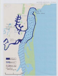
- Submission (see diagram)
2.1 That the 6 knots zone be extended 100 metres from the foreshore of the mainland from the existing zone to Lamerough Creek as far as Bells Creek. That the 6 knot zone be extended to include a 100 metres from the foreshore at the northern end of Bribie Island as far as the foreshore of Bribie Island opposite Bells Creek.
2.2 That the 6 knot zone be extended to include Bells Creek. (Blue part of map)
2.3 That the maximum speed limit for the remainder of waters in the Pumicestone Passage from the northern end of the Pumicestone Passage to Bells Creek be set at 20 knots for all motorised craft. (Spotted part of map)
2.4 That the designated water-skiing area and the area for motorised craft travelling in excess of 20 knots commence south of Bells Creek.
2.4 That the area south of Bells Creek be a dedicated 40 knot zone for motorised PWCs. (Striped part of map)

- Reason for the Change
Pumicestone Passage is part of the Moreton Bay Marine Park which was declared Ramsar Site number 41 in Australia on 22 October 1993. Pumicestone Passage is one of the few barrier estuaries in Australia. It is a unique wetland consisting of intertidal mudflats, salt marshes, tree and sedge swamps, sandflats, seagrass meadows and mangrove forests. This diversity allows it to be home to many species of plants and animals including 60 species of fish, 350 species of invertebrates, dugongs, turtles and 43 species of migratory waders and shorebirds. The Passage and most of the catchment are listed on the Directory of Nationally Significant Wetlands. Given Pumicestone Passage is a Ramsar Site the following concerns assume an even greater importance.
3.1 Increased Usage – an estimated 40% increase in motorised PWCs using the northern end of the Passage (especially from Military Jetty to Bells Creek) over recent years due to population growth in the area.
3.2 Maritime Safety – increase safety risk to swimmers, kayakers, paddle boarders, kite surfers and anchored boats from motorised PWCs travelling at high speeds.
3.3 Impact on Migratory and Shore Birds – the noise and speed of motorised PWCs disturb the bird population thereby causing them to expend energy resulting in weight loss. This reduces migratory birds capacity to manage the flight North. It is disturbing local bird roosts as evidenced by declining numbers of waders.
3.4 Noise Pollution – resident living near the mainland foreshore down to Bells Creek are increasingly impact by noise pollution from motorised PWCs.
3.5 Increased Erosion – with increased vessel usage and motorised PWCs travelling at high speed there is a growing erosion problem in the Passage and in the creeks that feed into the Passage.
3.6 First Nation Cultural Heritage – significant middens and scar trees have been identified along the Passage and in the riparian area along Bells Creek and these need to be preserved.
Conclusion
This submission has been initiated by (TAPP) Take Action for Pumicestone Passage inc. and has the support of the following community groups associated with the Northern end of Pumicestone Passage:
Sunshine Coast Environment Council
Night Eyes Water & Landcare
Caloundra Progress Association inc
Golden Beach and Pelican Waters Community Association inc
Golden Beach Sailing and Boating Club
Australian Naval Cadets
Golden Beach Neighbour Watch
Bribie Island Environmental Protection Association inc
Wildlife Preservation Society of Queensland
CPBC Fishing Club
Caloundra Catholic Community Social Justice Network.
Caloundra Outrigger Canoe Club (COCC)
This Submission is presented by The TAPP Executive, TAPP members and these twelve community groups who wrote letters supporting these changes to the speed limit at the northern end of Pumicestone Passage.
