Urgent Action Needed to oppose the inappropriate The Coochin Creek Developments still need your input.
We need the Development Application to be referred to the Environment Protection and Biodiversity Conservation ACT- a Federal Government Act which oversees developments in Nationally Significant Environments such as a Ramsar protected wetland. Write to Minister Murray Watt and insist that this development be referred under the EPBC Act.
Aerial view of Roy’s Farm in 2010 when cultivated for preparation of new Strawberry crop.
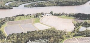
Aerial view of Roy’s Farm in 2010 when cultivated for preparation of new Strawberry crop.
The original strawberry farm run by the Roy family has been bought by the Comiskey Group of developers. This development was initially gazetted as a small eco village. However, the Comiskey Group have applied to change that site into a mega Tourist Park. The SC Council rejected the proposal without considerable changes. However Minister Jarrod Bliejie has called this development in. This means that the developers no longer need to comply with the stipulations required by Council. When this application was presented to the State Assessment and Referral Agency (SARA) – it too rejected the proposal saying it was in the wrong place and it would not be beneficial to the economy of the State. Despite this the minister is still going ahead with the plan to allow this to go ahead. The scale of the Tourist Park as well as the adjoining festival site makes it extremely unsuitable for this fragile site beside the Pumicestone Passage.
Any call in from a minister needs to be assessed on the basis that it is in the interest of the state in regard to economic benefit and environmental protection. Neither of these reasons can be justified. The State referral Agency SARA has decreed that Coochin Creek is not a suitable site for a major construction such as this – it would be more beneficial on a different site.
It is also not going to be beneficial to the state financially as it will be situated in an area that is difficult to access. It will most likely be an expense to be borne mostly by the SC Council residents in supply of water and removal of rubbish and effluent. Despite rhetoric about the available funds that the developer may have in reserve for this development; to comply with the regulations this group cannot achieve compliance through conditions. The damage will be inevitable.
The site directly adjoins the Ramsar-listed Pumicestone Passage, a wetland of international importance protected under the Environment Protection and Biodiversity Conservation Act 1999 (EPBC Act).
It is adjacent to both a Marine Conservation Park Zone and the Bribie Island Marine National Park. It lies within a protected greenbelt surrounded by Council and National Park reserves that were identified for their environmental significance. The Sunshine Coast Council itself sought to purchase this land to ensure its protection.
Under the Environment Protection and Biodiversity Conservation (EPBC) Act 1999, the proposal should have been referred to the Federal Department of Environment for assessment due to its proximity to Matters of National Environmental Significance (MNES), including habitat for threatened flora and fauna. This referral has not occurred. The area provides critical feeding and roosting habitat for migratory shorebirds, which are highly sensitive to human disturbance. Activities promoted within the development—such as boating, jet skiing, kayaking, and fishing—will disrupt these species and degrade essential habitat values.
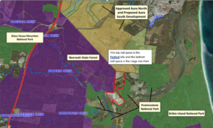
The proposed development sits wholly within the protected Northern Inter-Urban Break (NIUB) green belt, which serves as a permanent separation between Sunshine Coast and Moreton Bay urban footprints.
The (NIUB)—a legislated greenbelt separating the Sunshine Coast from Brisbane—protected under the Recreation Plan and Rural Landscape and Rural Production Area (RLRPA) designations. These frameworks explicitly restrict intensive tourism and urban-style developments. The developer, Comiskey Group, purchased the property with full knowledge of these restrictions and initially proposed a low-impact eco-resort.
The current proposal represents a significant departure from those conditions and undermines both local and state planning frameworks.
This scale and built form are inconsistent with the Planning Regulation 2017 definition of nature-based tourism and conflict with the Sunshine Coast Planning Scheme 2014, particularly the Strategic Framework Theme 3: Environment and Landscape, the Biodiversity, Waterways and Wetlands Overlay and most importantly the Flood Hazard Overlay.
Permitting a Big4-style tourist park would also set a dangerous precedent for incremental erosion of this strategic green belt.
The site lies within a low-lying floodplain connected to Coochin Creek and the Pumicestone Passage. The area is also identified under QCoast2100 as subject to coastal hazard and sea level rise exposure, rendering it unsuitable for semi-permanent accommodation. Intensified development will increase impervious surfaces, exacerbating flood and stormwater risk. The instance of severe weather is increasing. In 2022 Coochin Creek flooded causing the Bruce Highway to be closed to traffic.
The proposed sewage system would release up to approximately 60,000 litres of effluent per day across 2.5 hectares of adjoining land, posing an unacceptable risk to groundwater, wetlands, and the hydrological health of the Pumicestone Passage.
To allow this major construction in this flood prone area is tantamount to negligence on the part of the government agencies allowing this and the developer promoting it. The risk to the public and the environment is too great.
Roys Road (East) is a narrow rural connector with blind corners, limited shoulders, and two single-lane bridges—one within a flood zone.
A 150-site tourist park could generate potentially over 600 vehicle movements daily, posing safety hazards for residents, tourists, and wildlife. The site’s single ingress/egress in a bushfire-prone area compounds emergency access risk.
____________________________________________________________________________________
The statutory and strategic grounds against this proposal:-
- Conflict with the Sunshine Coast Planning Scheme 2014, including environmental, flooding, and landscape overlays.
- Non-compliance with the State Planning Policy (SPP) 2023 on matters of environmental significance and hazard resilience.
- Inconsistency with the SEQ Regional Plan 2023 protections for the Northern Inter-Urban Break.
- Potential contravention of Australia’s obligations under the EPBC Act regarding Ramsar wetlands and migratory species.
- inconsistent with State and Regional Planning frameworks, particularly the Northern Inter-Urban Break (NIUB) protections enshrined in the SEQ Regional Plan 2023 and Planning Regulation 2017.
The regulations are in place to protect the community. Ignoring the governance around the regulations is contrary to the Ministerial Code of Conduct.
Are these Ministerial Codes of Conduct being adhered to????
EXTRACT FROM PART 3 OF PUBLIC SECTOR ETHICS ACT 1994 Part 3, Division 2 Ethics Values Section 8, page 14 – which states ;-
Commitment to the system of government
- In recognition that the public sector has a duty to uphold the system of government and the laws of the State, Commonwealth and local government, public service agencies, public sector entities and public officials—
- accept and value their duty to uphold the system of government and the laws of the State, the Commonwealth and local government; and
- are committed to effecting official public sector priorities, policies and decisions professionally and impartially; and
- accept and value their duty to operate within the framework of Ministerial responsibility to Government, the Parliament and the Community.
Progressive Development of Southern Lakes Pelican Waters
The final stage of Pelican Waters development is the Southern Lakes section. This area comprises a canal and lake system with a Lock and Weir. It supports the installation of individual jetties for residents along the canal, a marina with the capacity for approximately 80 vessels and a “dry dock” stacker with a capacity for 200 plus vessels.
Changes to some of the original plans for Southern Lakes has resulted in the division of parkland, originally intended as sport fields in the centre of the development, to provide additional parkland along the canal to increase waterside recreational area.
In conjunction with the progress of the Canal development, an extension to Jensen Park is under construction. TAPP have been in discussion with Henzells during the design stage of the park. This will retain much of the original vegetation, with trimming the understory of the trees for wind flow to reduce mosquito activity. Combined in the design will be “bird hides”, Osprey nest areas and increased vegetation planting. It is envisaged that the local community may be involved with planting and restoring the original power line lease area.
TAPP meet with Henzells on a more regular basis now to discuss progress of this development.
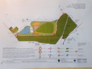
The site plans for Jensen Park Upgrade. Approximately 4 hectares of additional park.